

Partnerships for Environmental Public Health (PEPH)
Study Location: Imperial County, California
Academic Partners:
California Environmental Health Tracking Program (a collaboration of the Public Health Institute and the California Department of Public Health)
Paul English, Ph.D.
University of Washington
George Washington University
Community Partners:
Comité Cívico Del Valle Inc.
Z Data Solutions
Project Description
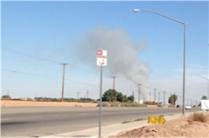
Agricultural burning is included in the hazard assessment mapping activity.
(Photo courtesy of Paul English)
This community-engaged project aims to reduce air pollutant exposures and improve the health of residents in Imperial County, California. It concerns a low-income, primarily Latino community, near the U.S.-Mexico border. The county has a long history of cumulative exposures, including poor air quality, and has one of the highest asthma hospitalization and emergency room visit rates in the state for school-aged children. For this project, the California Environmental Health Tracking Program — a collaboration of the Public Health Institute and the California Department of Public Health— is partnering with Comité Cívico Del Valle Inc., the University of Washington, and George Washington University.
The project is using community expertise to inform the placement of low-cost air quality monitors. New methods will be applied to combine data from the low-cost monitors with existing data sources to create high-resolution maps showing locations of air pollution over time. The project will also enhance a community-initiated online mapping tool by contributing real-time air quality data from the monitors. Ultimately, this work will build community capacity for hazard mapping and air monitor site selection related to environmental health research and action.
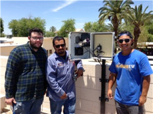
Students and school staff assist in the installation of an air monitor on the rooftop of Brawley Union High School.
(Photo courtesy of Paul English)
The goals of the project are to:
- Engage community members to define and map local hazards to highlight factors contributing to cumulative exposures and community vulnerability.
- Deploy a network of inexpensive real-time air monitors that will provide online data on regional air pollution levels.
- Apply state-of-the-art land use modeling to develop a detailed picture of particulate matter throughout the county to identify hot spots near vulnerable populations.
- Develop a community action plan for reducing exposures, improving health, and ensuring project sustainability.
- Conduct an evaluation of the project, including partnership processes, community involvement in the research, and resulting public health actions.