


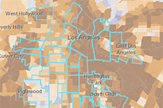
MADRES Center Maps Showing MADRES Neighborhoods (outlined) overlaid with Pollution Burden (brown; darker=higher burden)
(Photo courtesy of MADRES Center for Environmental Health Disparities)
The NIEHS-funded Maternal and Developmental Risks from Environmental and Social Stressors (MADRES) Center for Environmental Health Disparities has developed an interactive story map. It depicts how certain Los Angeles communities are faring during the COVID-19 pandemic.
The map provides visualization of environmental health disparities along racial and ethnic lines, susceptibility, built environment, and COVID-19 spread. The interactive map also shows COVID-19 testing sites, residential housing density, and the percent of workers who rely on public transit. Data are updated daily.
The MADRES Center’s goal is to use the map to improve environmental health literacy in communities experiencing health disparities. The interactive map, allows users to click on locations for more details about a particular community. The story map also has a list of resources, including information on COVID-19 and pregnancy.
The mapping tool can be used to inform vulnerable communities about MADRES research and outreach efforts. It also assists public health researchers obtain a deeper understanding of the intersectionality of socioeconomic factors, environmental exposures, built environment, and COVID-19. The MADRES Center hopes that the tool provides useful information to policymakers and community leaders and informs policies and public health efforts during and after the pandemic.
This mapping project was led by Rima Habre, Sc.D., an environmental health researcher at the University of Southern California Keck School of Medicine and director of the MADRES Center’s Exposure Core.